বনের টেকসই ব্যবস্থাপনায় আমাদের যা করতে হবে
Through a wide variety of mobile applications, we’ve developed a unique visual system and strategy that can be applied across the spectrum of available applications.
I use animation as a third dimension by which to simplify experiences and kuiding thro each and every interaction. I’m not adding motion just to spruce things up, but doing it in ways that.

I throw myself down among the tall grass by the stream as Ilie close to the earth.
We’ll handle everything from to app development process until it is time to make your project live.
We’ll help you optimize your business processes to maximize profitability and eliminate unnecessary costs.
Using our expertise in mobile application development to create beautiful pixel-perfect designs.
Your website ranking matters. Our SEO services will help you get to the top of the ranks and stay there!
A UX consultant is responsible for many of the same tasks as a UX designer, but they typically.

Through a wide variety of mobile applications, we’ve developed a unique visual system and strategy that can be applied across the spectrum of available applications.


Institute of Forestry and Environmental Sciences, Chittagong University (IFESCU)
Institute of Forestry and Environmental Sciences, Chittagong University (IFESCU)
Funded by : USAID
Funded by : SIDA
Funded by : UNHCR - The UN Refugee Agency
Funded by : Kwansei Gakuin University, Japan
Funded by : BCCP and John Hopkins University
Organizer: USFS and BFD
Organizer: USFS
Organizer: USFS, Green Savers
Organizer: USFS, Arranyak Foundation
Organizer: UNDP, IOM, UNOPS
Type: Report; Publisher : Compass, US Forest Service International Programs
Type: Report ; Publisher : UNDP Bangladesh
Type: Review article; Publisher: Geology, Ecology, and Landscapes- DOI: https://doi.org/10.1080/24749508.2018.148 1656
Type: MS Thesis; Publisher: Institute of Forestry and Environmental Sciences, University of Chittagong
Type: Undergraduate project paper; Publisher: Institute of Forestry and Environmental Sciences, University of Chittagong
Type: Management plan; Publisher: Institute of Forestry and Environmental Sciences, University of Chittagong
Type: Journal Article; Publisher: Indian Journal of Economics and Development. Available online at http://ijed.informaticspublishing.com/index. php/ijed/article/view/81514
Type: Poster Presentation; Publisher: Workshop on “Empowering Youth with Earth Observation Information for Climate Actions in Bangladesh”. Funded by ICIMOD, NASA and USAID in Collaboration with BCAS

Maecenas finibus nec sem ut imperdiet. Ut tincidunt est ac dolor aliquam sodales. Phasellus sed mauris hendrerit, laoreet sem in, lobortis mauris hendrerit ante. Ut tincidunt est ac dolor aliquam sodales phasellus smauris test

Maecenas finibus nec sem ut imperdiet. Ut tincidunt est ac dolor aliquam sodales. Phasellus sed mauris hendrerit, laoreet sem in, lobortis mauris hendrerit ante. Ut tincidunt est ac dolor aliquam sodales phasellus smauris test

Maecenas finibus nec sem ut imperdiet. Ut tincidunt est ac dolor aliquam sodales. Phasellus sed mauris hendrerit, laoreet sem in, lobortis mauris hendrerit ante. Ut tincidunt est ac dolor aliquam sodales phasellus smauris
All the Lorem Ipsum generators on the Internet tend to repeat predefined chunks as necessary
1 Page with Elementor
Design Customization
Responsive Design
Content Upload
Design Customization
2 Plugins/Extensions
Multipage Elementor
Design Figma
MAintaine Design
Content Upload
Design With XD
8 Plugins/Extensions
All the Lorem Ipsum generators on the Internet tend to repeat predefined chunks as necessary
5 Page with Elementor
Design Customization
Responsive Design
Content Upload
Design Customization
5 Plugins/Extensions
Multipage Elementor
Design Figma
MAintaine Design
Content Upload
Design With XD
50 Plugins/Extensions
All the Lorem Ipsum generators on the Internet tend to repeat predefined chunks as necessary
10 Page with Elementor
Design Customization
Responsive Design
Content Upload
Design Customization
20 Plugins/Extensions
Multipage Elementor
Design Figma
MAintaine Design
Content Upload
Design With XD
100 Plugins/Extensions

iTree is a web-based application that provides users with a comprehensive analysis of the benefits that trees provide to urban areas. The tool was developed by the US Forest Service in collaboration with several other organizations and is freely available to the public.

The iTree software uses inputs such as tree species, size, and location to estimate the environmental benefits that trees provide. Some of the benefits that are calculated include air pollution removal, carbon sequestration, energy savings, and stormwater mitigation.
One of the most significant benefits of iTree is its ability to quantify the monetary value of these benefits. This information can be used by urban planners, city officials, and other stakeholders to make informed decisions about the management and preservation of urban forests. For example, iTree can help determine the optimal location for tree planting projects, or it can be used to demonstrate the economic value of existing trees to local residents and businesses.
The iTree application is also an excellent educational tool. The software is user-friendly and can be used to teach students and community members about the importance of trees in urban environments. It can also be used to raise awareness about the need to preserve and protect urban forests.
iTree has been used in a variety of settings across the United States and in other countries. For example, the City of Philadelphia used iTree to conduct an assessment of the environmental benefits provided by trees in the city. The results of this assessment were used to develop a comprehensive urban forestry management plan for the city.
Overall, iTree is a powerful tool that can help promote the preservation and management of urban forests. Its ability to quantify the environmental and economic benefits of trees makes it a valuable resource for urban planners, city officials, and other stakeholders. By using iTree, communities can make informed decisions about the management of their urban forests, leading to healthier and more sustainable cities.

Google Earth Engine is a powerful cloud-based platform that enables users to analyze and visualize geospatial data. One of the most common applications of Earth Engine is crop classification, which involves identifying different types of crops Google Earth Engine is a powerful cloud-based platform that enables users to analyze and visualize geospatial data. One of the most common applications of Earth Engine is crop classification, which involves identifying different types of crops.
Remote sensing data, such as satellite imagery, can provide valuable information about crops and their growth patterns. For example, the reflectance of different crops at different wavelengths can be used to distinguish between different crop types. In addition, other information such as the timing of planting and harvesting, as well as the use of fertilizers and pesticides, can be inferred from the satellite data.
To perform crop classification using Earth Engine, the first step is to acquire the relevant satellite imagery. Google Earth Engine provides access to a wide range of satellite data, including Landsat, Sentinel-2, MODIS, and others. Once the imagery is loaded into Earth Engine, various preprocessing steps may be necessary, such as cloud masking and atmospheric correction.
Next, a classification algorithm is used to identify different crop types in the imagery. Earth Engine provides several algorithms for this purpose, including Random Forest, Support Vector Machine, and Maximum Likelihood. These algorithms use statistical and machine learning techniques to analyze the satellite data and classify each pixel into one of several crop categories.
Once the classification is complete, the resulting map can be visualized and analyzed within Earth Engine. The map can also be exported in various formats, such as GeoTIFF or KML, for use in other software packages.
One of the main advantages of using Earth Engine for crop classification is its scalability. Earth Engine can handle large amounts of data and perform computations in parallel, which makes it possible to analyze vast areas of land in a relatively short amount of time. In addition, Earth Engine provides access to a wide range of ancillary data, such as climate and soil data, which can be used to improve the accuracy of the crop classification.
Another advantage of using Earth Engine is the ability to perform time-series analysis. By analyzing satellite data over time, it is possible to track changes in crop growth and identify trends and patterns. This information can be used to inform decision-making in areas such as agriculture, land use planning, and environmental management.
In conclusion, Google Earth Engine is a powerful tool for crop classification and analysis. Its scalability, machine learning algorithms, and access to ancillary data make it a valuable resource for researchers, policymakers, and others interested in understanding and managing crop production.

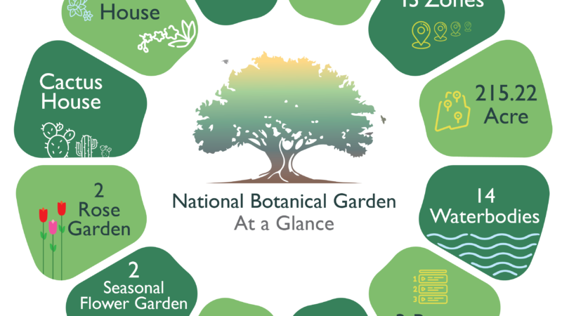
Bangladesh National Botanical Garden, located in Mirpur, Dhaka, is a beautiful and serene oasis in the midst of the bustling city. Established in 1961, the botanical garden is spread across an area of 215 acres and houses a vast collection of plants, trees, and flowers from Bangladesh and around the world.
The garden has over 50,000 plant specimens and over 100,000 visitors every year. It serves as a research center for botanists and researchers from all over the world who come to study and explore the flora of Bangladesh. It also provides a peaceful and relaxing environment for nature lovers and tourists to escape the chaos of the city.
The botanical garden is divided into several sections, each with its own unique collection of plants and trees. The Medicinal Plant Garden is home to over 200 species of plants that are used in traditional medicine to treat various ailments. The Palm House is a must-visit section, featuring a stunning array of palm trees from around the world.
The Orchid House is another popular section that showcases over 200 species of orchids, including the rare and endangered ones. The Rose Garden is a favorite among visitors, especially during the winter season when the roses are in full bloom.
Apart from the different sections, the botanical garden also has several lakes, ponds, and streams that add to the beauty and tranquility of the place. It’s a great place for picnics, walks, and photography, as there are plenty of picturesque spots throughout the garden.
Overall, the Bangladesh National Botanical Garden is a must-visit destination for anyone visiting Dhaka. Its diverse collection of plants, serene atmosphere, and beautiful surroundings make it a perfect escape from the city’s chaos. So if you’re in Dhaka and looking for a peaceful and relaxing place to spend some time, head over to the botanical garden and immerse yourself in the beauty of nature.

I am available for freelance work. Connect with me via and call in to my account.
Phone: +012 345 678 90 Email: admin@example.comWelcome